Showing posts with label Philippines 25. Show all posts

Philippines - Colonial Urban Plan and Fortifications of the Walled City of Manila

"Shaped like an irregular pentagon, the Historic Center of Manila, known since the late 19th Century as Intramuros, is a 0.67 square kilometer area tied to and woven with the country’s historical narrative from the pre-colonial period to the present. For more than three centuries it was the capital of the Spanish colonial empire in the Far East. It captures, as a landscape, various layers of significance as a witness to the transformative social, historical, economic, religious, and political events of the City of Manila and of the Philippines itself as a result of the intersection between the cultures of Asia, Europe, and America – the primary locus of trade, connection, and competition between these continents in the Western Pacific. Its utmost value is found in being an enduring witness to the confluence of trade and history between continents and peoples."

Source: UNESCO World Heritage Tentative List


Postcard 1
I visited this famous fort in Manila - Intramuros area. Thanks to Dermawan for mailing with stamp of Philippines Miss Universe 2018 of Catriano Gray.


Postcard 2
Intramuros Manila. 

Philippines - Corregidor Island and Historic Fortifications of Manila Bay

"Corregidor Island is a 5.5 square kilometer island at the entrance of Manila Bay in the Philippine island of Luzon located 42 kilometers from the City of Manila. It was a heavily fortified island built tactically and strategically as part of the Harbor Defense of Manila Bay. Corregidor (Fort Mills) was the largest of the four harbor defense fortifications in Manila Bay, that also included El Fraile Island (Fort Drum), Caballo Island (Fort Hughes), and Carabao Island (Fort Frank), that were all fortified during the colonial administration of the United States in the Philippines."

Source: UNESCO World Heritage Tentative List


There is a historical war tour to the Corregidor Island. As Philippines was an American colony during World War II, there were major battles. General MacArthur gave his famous quote, "I shall return"....Thanks to Victor of Singapore for sending this wonderful postcard.


Philippines - The Historic Towns and Landscape of Taal Volcano and its Caldera Lake

"Taal Volcano Protected Landscape — Taal Volcano and Taal Caldera Lake (Cities of Lipa, Tagaytay, and Tanauan, Municipalities of Agoncillo, Alitagtag, Balete, Cuenca, Laurel, Lemery, Malvar, Mataas na Kahoy, San Jose, San Nicolas, Santa Teresita, Taal, and Talisay):  Historic Town of Taal: San Nicolas Ruins.

Taal is an active volcano within a massive caldera, with at least 38 recorded eruptions in the last 450 years. Its most recent major eruption in 2020 prompted evacuations in its surrounding communities while spreading ash across neighboring provinces and regions, including Metro Manila. This eruption had a significant impact on transportation, government, business, and education activities, affecting tens of millions of individuals.

Source: UNESCO World Heritage Tentative List


Beautiful postcard of the crater lake of Taal Volcano - a day trip from Manila, Philippines. Wonderful Year of Ox stamps! Thanks to Bob of Manila. Interesting to note that Philippines postmark ink is purple in color. Postmarked March 13, 2009 - arrived March 20, 2009.


Philippines - Mayon Volcano Natural Park

"The Mayon Volcano is situated in the southern part of the main island of Luzon, 500 kilometres south of Manila. Towering at a height of 2,462 meters above sea level, it is known for its perfectly conical shape whose natural beauty has inspired a number of legends and art. The most active volcano in the Philippines and one of the most active in the world, having erupted over 51 times in the past four centuries, the most destructive of which is in 1814 when five towns in its periphery were destroyed. Nevertheless, it has developed a culture of resiliency among the inhabitants of its vicinity, who always rebuilt their towns and cultivated their fields after each destructive eruption."

Source: UNESCO World Heritage Tentative List

Postcard 1
Mayon Volcano during it eruption. Located near Legazpi City, Daraga Albay, Luzon Island. Mayon derived from Bicol word "mangayon" which means "beauty". It was considered the be the world's most perfectly formed volcano. Thanks so much to Walter of Philippines.


Postcard 2
Mount Mayon of southern part of Luzon island, Philippines is considered one of the most perfect cone. Followed by Mt. Fuji of Honshu Island, Japan and Mt. Pico of Azores, Portugal. Nice bird stamps. Thanks so much to "Bradpete" of Philippines. Salamat.
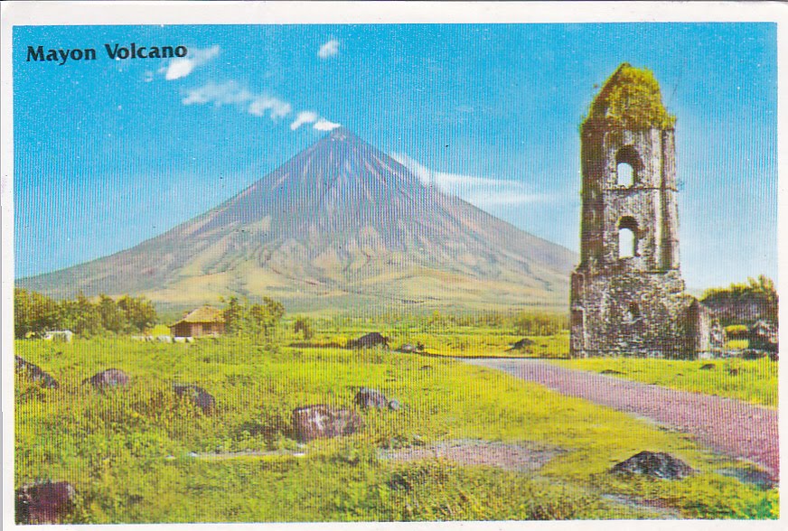


Postcard 3
Ruins of Cagsawa Church, the only surviving structure in 19th century major eruption with Mount Mayon in the background. Thanks to Walter of Philippines. Salamat.

Philippines - Prehistoric Sites of the Cagayan Valley Basin

"Paleolithic Sites of the Callao Limestone Formation
Paleolithic Sites of the Awidon Mesa Formation - Lanna, Andarayan, and Nangalisan: Kalinga Archaeological Site
Lal-lo Neolithic Shell Midden Sites (Nagsabaran, Magapit, and Bangag, Lal-lo, Cagayan) and Gattaran Neolithic Shell Midden Sites (Gattaran, Cagayan)

 The Cagayan Valley Basin encompasses extensive and crucial archaeological sites in the Philippines. Research and excavations by the National Museum of the Philippines (NMP), and field research by the Cagayan Museum have yielded vast archeological findings including artifacts and traces of the past that date back to several periods: the Paleolithic Age, around 700,000 years ago when early humans navigated a different landscape; the Neolithic Age, a time when humans started to produce their own food through domestication of plants and animals; and Metal Age which covers the transition from 2000 Before Common Era (BCE) to 1000 Common Era (CE). Cagayan Valley, like many other provinces in the Philippines, was never isolated from foreign influence as was earlier believed. It was once a part of the long prehistoric international trade with neighboring countries from around the 10th to 16th century CE."

Source: UNESCO World Heritage Tentative List


Callao Cave in Cagayan, Philippines. Thanks to Harry of Philippines.

Philippines - Baroque Churches of the Philippines (Extension)

"1) Church complex of Patrocinio de Maria, Boljo-on (Cebu) The church structure and complex still boast of its original features; the roof, walling, ceiling, ornamentation, and setting. Repairs that were done in the recent years, but these repairs did not affect the integrity of the church and setting. The design of the structure, use of materials is in conformity with the setting and location. To date it is still used as a church and convent. 

2) Church of La Inmaculada Concepcion, Guiuan (Samar) The church of Guiuan has undergone further improvements in the 1930's when the present ceiling of the church was painted and the flooring was done. There are repairs every now and then, but the main context of the structure remained. The seashell ornamentation and the church artifacts are intact. The fortress is still in the periphery. Based on an early 20th century picture, the church maintained its integrity. Reflective of the Jesuit and Franciscan sensibilities. 

3) Church complex of San Pedro Apostol, Loboc (Bohol) The church complex of Loboc maintained most of its original features. Based on an early 20th century photograph, the church appeared the same. There appeared that no major works was done in the church except for the replacement of the roof. Generally, the features are intact, and most of the additions / repairs are reversible. With sensibilities of the Jesuit and Augustinian Recollects. 

4) Church complex of San Isidro Labrador, Lazi (Siquijor) The setting of the church complex remained the same as to when it was built in the 19th century. There are slight modifications made in the convent, but the traces are still there. 5) Church complex of San Mattias, Tumauini (Isabela) Though damaged in the Second World War, the church retained / preserved most of the undamaged walls. The damaged part of the church was repaired."

Source: UNESCO World Heritage Tentative List 
Postcard 1
San Pedro Apostol, Loboc Church is located in Bohol. Thanks to Harry of Philippines.


Philippines - Batanes Protected landscapes and seascapes

"DescriptionCharacterized by a complex of terrestrial, wetland and marine ecosystem, the Batanes group of islands consist of 10 small islands bounded by the Eashi Channel on the north, by the Pacific Ocean on the east, by the South China Sea on the west and the Balintang Channel on the south. It is one of the last remaining areas in the Philippines having unique natural physiographic features (wave-cut cliffs, cave-like outcrops, secluded white sand beaches) resulting from its position where strong winds and fast currents have etched out its distinct morphology. It is an important flyaway for many migratory bird species, and the deper portions of the marine environment are the few remaining sites where pink and red corals (Corallum sp.) are found. The site is the only area in the Philippines where traditional architecture is of stone in response to the wind and monsoon stresses rather than of the more typical, tropical, impermanent materials (wood, bamboo, thatch) cxommonly used in village architecture. Due to its isolation from the rest of the country, the traditional culture of the area has likewise remained intact." Source: UNESCO World Heritage Tentative List

Basco, Batanes is located at northern part of Bataan - the second largest island among the Batanes Island, Philippines. Thanks to Jeff of Philippines.


Philippines - Coron Island Natural Biotic Area

"Coron Island is roughly equidistant from Manila and Puerto Princessa City. The Island has a rugged topography, generally mountainous and its terrain marked by steep rock and ravines. Almost 70% of the area made up of rocky cliffs, 25% is rolling hills and 5% relatively flat. Out of the total area, approximately 18% is occupied by the Tagbanua as residential and agricultural lands, as rock formations almost dominate the entire area. Large area is composed of Karst formations where swiftlets dwell and build their nest (birds nest). There are vertical limestone cliffs that reach up to 600 meters above sea level and eight (8) brackish lakes and three (3) smaller one's that have underground connections to the sea. Coron Island comprises two barangays, Banuang Daan and Cabugao, all of them belong to the Indigenous Cultural Communities. There are 373 households with a population of 2,028 individuals of Tagbanua in the Island. The primary users of the resources of the island are the residents of these two settlements. Majority of the residents of the two barangays are seldom seen in the mountains except for the gatherers of edible bird's nests on towering cliffs that serve as the major source of income for Indigenous people in the island. Coron Island is wedge-shaped limestone island, dominated by Permian Limestone of Jurassic origin, with few of its coastal areas being covered by mangrove forests. It is situated in the Calamianes group of Islands and belongs to the Municipality of Coron..." Source: UNESCO World Heritage Tentative List

Banol Beach, Busuanga, Coron, Palawan. 3 nice sea creature stamps with standard purple color cancellation. Postmarked January 17, 2011 Davao and arrived in Penang on January 25, 2011. Thanks to Ritz of Philippines. Salamat.


Philippines - El Nido-Taytay Managed Resource Protected Area

"The El Nido-Taytay Managed Resource Protected Area is located on the north-western tip of the mainland of Palawan. In 1991, the Government of the Philippines proclaimed Bacuit Bay as a marine reserve. In 1998, the protected area was expanded to include terrestrial ecosystems and portions of the municipality of Taytay. It is now known as El Nido-Taytay Managed Resource Protected Area, which covers over 36,000 hectares of land and 54,000 hectares of marine waters. It contains towering limestone cliffs, beaches, mangroves, clear waters, unique forests over limestone and neat farmlands. It is home to five (5) species of mammals, including the Malayan Pangolin and 16 bird species endemic to Palawan including the threatened Palawan Peacock Pheasant, the Palawan Hornbill and Palawan Scops Owl. Bacuit bay is also home to the dugong, dolphins and marine turtles, many of which are threatened species. Colorful coral reef fishes are found here. Some of these are the: butterflyfishes, parrotfishes, wrasses, triggerfishes, angelfishes, surgeonfishes, damsel fishes, emperors,snappers, groupers and rabbit fishes..."

Source: UNESCO World Heritage Tentative List


Postcard 1
Big Lagoon of Miniloc Island, El Nido, Palawan. Thanks to SI who went on holiday to Philippines.


Postcard 2
One of Palwan's virgin islands in El Nido. Thanks to SI.

Philippines - Mt. Pulag National Park

"Mt. Pulag National Park lies on the north and south spine of the Grand Cordillera Central that stretches from Pasaleng, Ilocos Norte to the Cordillera Provinces. Mt. Pulag National Park is the highest peak in Luzon and is the second highest mountain in the Philippines with an elevation of 2,922 m. above sea level. The summit of Mt. Pulag is covered with grass and dwarf bamboo plants. At lower elevations, the mountainside has a mossy forest veiled with fog, and full of ferns, lichens and moss. Below this is the pine forest growing on barren, rocky slopes. Falls, rivers and small lakes mark the area. The Park has a large diversity of flora and fauna, many of which are endemic to the mountain. Its wildlife includes threatened mammals such as the Philippine Brown Deer, Northern Luzon Giant Cloud Rat and the Luzon Pygmy Fruit Bat. One can also find several orchid species some of which are possibly endemic to Mt. Pulag, and other rare flora such as the pitcher plant." Source: UNESCO World Heritage Tentative List

Nice multi-view of Mount Pulag National Park. Stamps of children painting and definitive stamps of pencil urchin and lionfish used. Postmarked September 21, 2010 and arrived in Penang on September 28, 2010. Thanks to Anne of Philippines. Salamat.


Philippines - Chocolate Hills Monument

Chocolate Hills are mounds of limestone formations consisting of over 1268 hyacock hills ranging from 40-120 meters and turning brown during the dry season. Nice underwater stamps of Yellow Seahorse, Giant Clam and Lionfish used. Thanks to Len of Philippines. Salamat.