Showing posts with label China 59. Show all posts

China - Slender West Lake and Historic Urban Area in Yangzhou

"Slender West Lake, formerly Baozhang Lake, is located in the northwest of Yangzhou City, Jiangsu Province, covering an area of two square kilometers. In the mid-18th century, the moats and a large number of suburban villas of salt traders along the moats built in different locations and in different historical period (Sui, Tang, Song, Yuan, Ming and Qing dynasties) were connected elaborately and delicately to welcome the south inspection of Emperor Qianlong, thus forming a beautiful belt of the lake with garden scenery combining natural and human landscapes characterized by the most famous 24 scenes of "rolling stone archway, winding water in west park, spring pillow on the long bank, bright cloud in white pagoda" etc....

The historic urban area in Yangzhou refers to the Yangzhou City built on the basis of Luocheng City of the Tang Dynasty and Dacheng City of the Song Dynasty in the Ming and Qing dynasties covering an area of 5.09 square kilometers which made great contributions to the economic, political and cultural development of Chinese feudal society and had a significant impact on world culture. Relying on its highly developed salt economy, Yangzhou still kept strong vitality and had a great influence in the Ming and Qing dynasties..." 

Source: UNESCO World Heritage Tentative List

Postcard 1
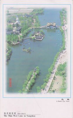
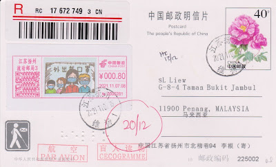
Received a nice registered postcard of famous lake view of Yangzhou, Jiangsu, China with special Covid-19 themed pictorial postage printed label used. There is even a Braille embossment. Thanks to Li of Yangzhou, China. Postmarked Yangzhou November 7, 2021 and arrived on December 14, 2021.


Postcard 2
View of Slender West Lake - a find day after sonow in early spring of Twenty four Bridge Scenic Zone. Thanks to Wang of Jiangsu, China who visited here.


China - Huangguoshu Scenic Area

"Yunnan-Guizhou Plateau is located in the south of China. It belongs to the watershed region in the karst plateau rising between Sichuan Basin and Guangxi Hill. Since the Tertiary Period, with the strong neotectonic uplift of Himalayan orogeny and tropical and subtropical humid climates, the strong erosion of the northern Yangtze River system and the southern Pearl River system has formed the plateau-gorge landform structure, which is often distinguished by the geomorphological erosion cycle knickpoint type waterfall. The plateau-gorge landform structure is composed of two significantly different but closely related geomorphic units - the plateau area and the gorge area. In the background of the special regional units, Huangguoshu Scenic Area is created with completely different but closely related landform type, development and evolution, landscape characteristics, living environment, human habitation, land use, and regional culture."

Huangguoshu Scenic Spot: - Huangguoshu Waterfall - Dishuitan Waterfall - Gaodang Ancient Village

Getuhe Scenic Spot:

Tunpu Scenic Spot: - Yunshantun-Benzhai Ancient Village - Baojiatun Ancient Irrigation System - Tiantaishan Ancient Temple

Source: UNESCO World Heritage Tentative List

Huangguoshu Waterfall of Guizhou is one of the biggest waterfalls in China. It is 70m long and 81 m wide during the flood season. Another postcard that I bought in Beijing, China.

China - Scenic and historic area of Sacred Mountains and Lakes (Burang, Tibet)

"Located in Burang County, Ngari Prefecture of Tibet Autonomous Region, at an elevation of over 4,500 m, Scenic and historic area of Sacred Mountains and Lakes is adjacent to Zanda County, Gar County and Gya'gya County, bordering on India and Nepal. ‘Two peaks perching to the north and south, two lakes reflecting with each other in the east and west’ describes the basic natural landscape features of the property, comprising a fairly compact geomorphology unit of ‘two mountains with two lakes in between’, also resulting in unique landscape composed of glaciers, lakes, wetlands and grasslands in this region. ‘Two mountains’ means the Sacred Mountain of Gang Rinpoche (6,638m) and the Goddess Peak of Naimona'nyi (7,694m), and ‘two lakes’ refers to the Holy Lake of Manasarovar and the Ghost Lake of Lhanag-tso. Unique natural environment has bred particular and rich religions and cultures, which is of world-class Outstanding Universal Value." 

Source: UNESCO World Heritage Tentative List


Postcard 1
Mt. Gang Rinpoche from the postcard booklet Tibet Posture that I bought in China.


Postcard 2
Lake Mapham Yutso is another name of Holy Lake of Manasarovar, Tibet.

China - Tulin-Guge Scenic and Historic Interest Areas

"From natural perspective, in the nominated property there is a specific geomorphology type named “forest soil”, which presents outstanding universal value aesthetically and geologically. The lacustrine sedimentary around Zhada Basin and Sutlej River Basin of the nominated property belongs to the forest soil type but exhibits distinctive features, making a “Guge type”. The “Guge type”, composed of semi-consolidated lacustrine fluvial clay, sand and gravel, taking “pagoda forest” as the basic structural unit, was formed under dry climate, dominated by construction joints, affected by river erosion, rain shower eclipse and freezing weathering. The forest soil around Zhada County is tall and straight, composed of varied types, which shows distinctive aesthetical characteristics against the specific extreme natural environment of Qinghai-Tibet Plateau. The nominated property shows different hues, bedding structures and physical composition, among which there are a large quantity of fossils, presenting direct or indirect proofs of ancient environmental evolution of the Qinghai-Tibet Plateau." 

Source: UNESCO World Heritage Tentative List

Postcard 1
3 postcards from the postcard booklet "Tibet Posture" that I bought in China. The ruins of Guge Kingdom, Ngari, Tibet, China.


Postcard 2
The Earth Forest of Zada, Ngari, Tibet


Postcard 3
The site of ancient Zada fortress in Ngari, Tibet

China - The Four Sacred Mountains as an Extension of Mt. Taishan

"Application of "Four Sacred Mountains as an Extension of Mt. Taishan" is an extension application of Cultural and Natural World Heritages of Mt. Taishan. "The Five Sacred Mountains of China" is a cultural integration with long history. Mt. Taishan of "The Five Sacred Mountains of China" has already been listed on the World Heritages in 1987. And the four nominated sites for application include: 

Southern Mt. Hengshan (Hunan Province), 

Western Mt. Huashan (Shaanxi Province), 

Central Mt. Songshan (Henan Province) 

Northern Mt. Hengshan (Shanxi Province). 

The core scenic area of the four nominated sites is 54769 ha, and total buffering area is 44658 ha.

"The Five Sacred Mountains" has been worship for over three thousand years from Neolithic Age due to its unique geographical locations and majesty of relative altitude over a kilometre. In 219 BC, Qin Shihuang (First Emperor of Qin Dynasty) held a ceremony of offering sacrifices on the top Mt. Taishan when special national sacrifice codes and systems originated, which was followed by later emperors to show their imperial power's validity and authority. Offering sacrifices to Five Sacred Mountains was held to make the emperors'' achievements informed to all the people and Five Sacred Mountains were regarded as boundaries of their reign. Therefore, as an integration which cannot be divided, Five Sacred Mountains symbolizes the unification and territory in the era of Chinese agricultural civilization."

Source: UNESCO World Heritage Tentative List


Postcard 1 - Northern Hengshan
Mid-air temple of Nothern Hengshan, Shanxi, China. It is a postcard from the postcard set of Scenery of Shanxi that I bought in China.


Postcard 2 - Western Huashan
Hua Shan at 2154.9m is one of China top 5 mountains. Thanks to Liu Xu of China.


Postcard 3 - Central Songshan
View of Songyue Pagoda, a sixth century Buddhism temple, of Mount Song, Henan. Thanks to Christie of China.


China - Tianzhushan

"Located in Qianshan County, Anhui Province, Tianzhushan has both pleasant ecological environment and profound historical culture. It is a large mountainous landscape, dotted with granite peaks and caves, waterfalls and springs, which is the most beautiful granite along Tan-Lu fault zone. Tianzhushan is rich in geoheritage such as mammalian fossils and an ultrahigh pressure (UHP) metamorphic belt of eclogite, an unusually dense rock important for driving convection within the solid Earth. Tianzhushan has profound cultural landscapes with a long history. It is the cradle of Hui Culture. Xuejiagang Culture discovered in Xuejiagang site is the only Neolithic culture in Anhui province and the origin of ancient culture of Anhui province. The Cliffside stone inscription recorded the inscription art for 1200 years. Sanzu Temple has an extremely important status and influence in the Tianzhushan religious culture. The nominated property is the area where he first long narrative poem Peacocks Flying Southward took place."

Source: UNESCO World Heritage Tentative List

Tianzhu Mountain, Anqing, Anhui. Nice dinosaur stamps. Thanks to "Atp" of China.

China - The Chinese Section of the Silk Roads

Land Route of the Silk
Henan Province
Gongyi Stone Cave Temple - Luoyang City
Luoyang city of Han and Wei Dynasties - Luoyang City
City of the Sui and Tang Dynasties - Luoyang City
White Horse Temple - Luoyang City
Han'gu Pass and Xiaohan Ancient Path in Han Dynasty Shaanxi Province
Site of the Chang'an City of Han Dynasty - Xi'an City
Mao Imperial Mausoleum of Han Dynasty and Tomb of Huo Qubing - Xingping City
Tomb of Zhang Qian - Hanzhong City
the Dagoba of Kumarajiva - Xi'an City
Site of the Chang'an City of Tang Dynasty - Xi'an City
Xingjiao Temple Pagoda (Xuan Zang's Dagoba) - Xi'an City
The Underground Chamber of Famen Temple - Baoji City
Daqin Monastery Pagoda - Xi'an City
Zhao Imperial Mausoleum - Xianyang City
Qian Imperial Mausoleum - Xianyang City
Great Buddha Temple Grottoes in Bin County - Xianyang City
Xi'an Mosque - Xi'an City

Ningxia Hui Autonomous Region
Historic City of Guyuan - Guyuan City
Cemetery of Northern Dynasties and Sui and Tang Dynasty in Guyuan - Guyuan City
Site of Kaicheng - Guyuan City
Mount Xumi Grottoes - Guyuan City

Gansu Province
Maijishan Grottoes- Immortal Cliff Grottoes - Tianshui City
Shuiliandong (Water Curtain Cave) Grottoes- Lashao Temple - Tianshui City
Bingling Temple Grottoes- Xia Temple - Linxia Hui Autonomous Prefecture
Site of Yunen Gate and Hecang City - Dunhuang City
Suoyang City Site and Tomb Complex - Jiuquan City
Camel City Site and Tomb Complex - Zhangye City
Guoyuan- Xincheng Tomb Complex - Jiayuguan City
Great Buddha Temple - Zhangye City
Mati Temple Grottoes- Jiata Temple and Qianfo (thousand Buddhas) Cave - Zhangye City
Yulin Grottoes - Jiuquan City
Xuanquanzhi Site - Dunhuang City

Xinjiang Uygur Autonomous Region 
Ancient City of Jiao River - Turpan City
Ancient City of Gaochang and Astana Cemetery - Turpan City
Taizang Tower - Turpan City
Buddha Subash Temple Site - Aksu Area
Ancient City of Loulan - Ba YinGuoLeng

Mongolia Autonomous Prefecture
Niya Site - Hetian Area
Kizil Grottoes - Aksu Area
Kumtula Grottoes - Aksu Area
Simsem Grottoes - Aksu Area
Bezeklik Grottoes - Turpan City
Toyuk Grottoes - Turpan City
Mehmud Qeshqeri Tomb - Kashgar City


Sea Route of the Silk Road
Ningbo City
Quanzhou City


The Silk Road is the ancient trade route that starts in the old capital of Chang'an, the present-day Xi'an city and the center of politics, economy, and culture in a long period of ancient China. It refers to the overland commercial route connecting Asia, Africa and Europe, which goes over the Longshan Mountain, follows Hexi Corridor, passes Yumenguan Pass and Yangguan Pass, reaches Xinjiang, stretches along the oasis and the Pamir Plateau, enters the Central Asia, crosses Central Asia, Western Asia and Southern Asia, and then leads to Africa and Europe. It also served as an important trunk road where the economic, political and cultural exchanges between the Orient and the West were taking place. In its very first beginning the function of the trade route is to transport silk, the fine, delicate, elegant and portable goods, representing the civilization of ancient China which enjoyed advanced agriculture and well-developed handicraft industry. Therefore, when the name of "Silk Road" was first given by the German geographer Ferdinand Freiherr von Richthofen in the 1870s, it was widely accepted.

Source: UNESCO World Heritage Tentative List


Quanzhou was once the largest maritime post in China before the Ming Dynasty. Thanks to Phoebe of Hong Kong.
China - Western Xia Imperial Tombs

"The Tangut civilization, an ethnic minority civilization, prospering in an agricultural-husbandry area in Northwest China, shows its excellent adaptability and outstanding cultural diversity. The general layout of the Tombs imitates the imperial mausoleum construction of the Northern Song Dynasty. In terms of site selection, layout, burial ways, building techniques and arts, the builders not only learned the experience from the ritual system and cultural achievements of the Northern Song Dynasty but also combined their own ethnic customs such as mountain worship, belief in necromancy and aesthetic orientations, reflecting the strong characteristics of the Tangut civilization’s inclusiveness and cultural fusion. As the site of the large tomb group for the Western Xia emperors, the Tombs bear special witness to the long vanishedTangut civilization."

Source: UNESCO World Heritage


I bought this postcard in China.

China - Site of Southern Yue State

"The archaeological sites of the Southern Yue State (the palace of the Southern Yue State, the tomb of the Southern Yue King, and the wooden Watergate of the Southern Yue State), situated at Yuexiu District, Guangzhou, Guangdong Province P.R. China. The Southern Yue State (203 B.C.-111B.C.) was a vassal state founded in the southern China during the early years of the western Han Dynasty. Its establishment accelerated the leap of development in social history in Lingnan region from the primitive society to the feudal society.

The tomb of the Southern Yue King was discovered in 1983, which ranked one of the top five important archaeological discoveries of China in the 1980's. It's by far the largest intact tomb of colour-painted stone chamber with the richest burial articles. Over 1000 pieces (or sets) of cultural relics were unearthed from the tomb, which were of great variety including ritual and musical instruments, weapons, food vessels, cloths, life utensils, jade carvings and gold and silver works." Source: UNESCO World Heritage Tentative List


Site musuem collection of open-work double drage jade pendant, width: 10.1cm. Thanks to Johnson of Hong Kong who visited one of the Southern Yue sites.

China - Maijishan Scenic Spots

"Maijishan Mountain is placed on the first list of state key scenic spots by its peculiar grottoes, exquisite clay sculptures luxuriant vegetation, all kinds geologies and landforms, mountain peaks. Its main area is 142km2 including Maijishan Grottoes, the Immortal Cliff, the Stone Gate, Quxi Stream and Jieting Hot Spring. Maijishan Grottoes was first built in Later Qin (384-417.D) constructed successively during the 12 dynasties which are West Qin, Northern Wei, West Wei, Northern Zhou, Sui, Tang, Five Dynasty, Song, Yuan, Ming and Qing. Although many earthquakes and conflagration, it still remains 194 caves, 7200 sculpture, 1000 square M fresco which are excatived on the cliff about 30-80m high form the ground, more than 70 percent caves were excavated in the North dynasty. When clay sculpture were popular, well-shaped and excellent art, They reach the climax of sculpture works in early period. Qinling chains in scenic area are the main boundary between North and South nature geography. There are two plant areas, China-Japan, China-Himalayas areas. They include much kind of plants of North China, Central China, and Himalayas. Menxinduo Higher plant.." Source: UNESCO World Heritage Tentative List
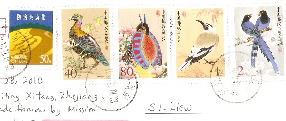
I bought these Maji-shan postcards in Shanghai in November 2011.


China - Poyang Nature Reserve

"Situated in northern Jiangxi,Poyang Lake, the largest fresh water lake in China, lies to the south of the middle and lower reaches of the Changjiang River. The lake has been well known as "a land of abundance" and is reputed as a "bright pearl" in the basin of the Changjiang River with its rich aquatic resources and flourishing crops in surrounding fertile lands. The lake area enjoys a subtropical warm and wet climate with suffucuent sunshine, ample precipitation and long frost-free period.  In the dry season of winter and spring, the water recedes and seasonal small lakes and large marshes appear all over the lake area. According to preliminary survey, there exist in the lake 25 families of phytoplankton totalling almost 100 species, the dominant being green algae,37 families of aquatic vascular plant with 98 species, the dominant being sedge, Potamogeton malaianus and Vallisneria spiralis; 65 species of mollusca, the dominant being snail and mussel; 21 families of fish with 122 species, the dominant being Cyprinidae. In addition, there is a good supply of silver fish, a famous product of the area. Spreading on the grassland along the banks are 74 species of 25 families of meadow and helophyte plants, the dominant being Gramineae, Cyperaceae, Polygonaceae and Compositae. Such abundant natural resources provide a welcoming habitat for birds, attracting tens of thousands of migratory birds to spend their winter there, thus turning the Poyang Lake into one of the world's most famous migratory birds sanctuaries..." 

Source: UNESCO World Heritage Tentative List

Birds at Poyang Lake. Thanks to Stanley of China.

China - The Alligator Sinensis Nature Reserve

"The Alligator Sinensis distributed in the lower reaches of the Yangtze River is a peculiar wildlife in China. The Alligator Sinensis, one of the fresh water crocodiles in the alligator family, have a history of 200 million years. There are only two species of this family in the world today, one is the Alligator Sinensis in China and the other is Alligator mississippiensis in the Mississippi River of north America. Having a gentle disposition and no harm to the people, the Alligator Sinensis is one of the rare animals in the world. According to the field survey, the Alligator sinensis is only distributed over the southern part of Anhui Province and some places of the neighbouring province of Zhejiang, totalling about 500 pieces.." Source: UNESCO World Heritage Tentative List

A nice maxicard of Alligator Sinensis. Thanks to Stanley of China.

China - Dong Villages

Description 
Shudong Village:
 Dali Village: 
 Zadang Village: 
 Village:N 25°57′37″, E 108°44′11″ 
 Zengchong Village:
 Tang’an Village:
 Xiage Village:
 Gaoqian Village:
 Zhanli Village:
 Ma’antun, Pingyan Village:
 Pingzhai, Pingyan Village:
 Yanzhai, Pingyan Village:
 Gaoxiu Village:
 Gaoyou Village: 
 Gaoshang Village:
 Kezhong Village:
 Gaosheng Village:
 Yanglan Village:
 Pingtan Village:
 Hengling Village:
 Yutou Village:
 Shangbao Village:

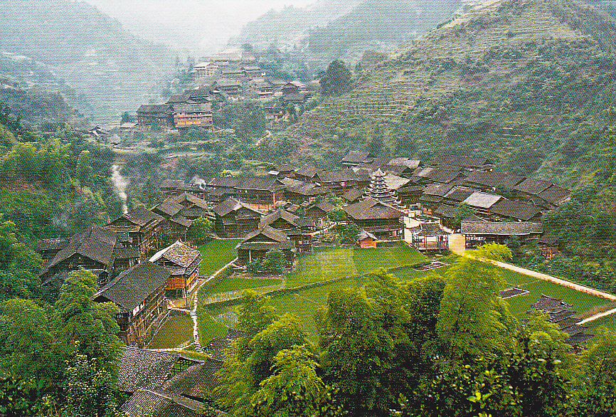
 The nominated Dong Villages were located in southwest China, and under jurisdiction of Liping County, Rongjiang County and Congjiang County in Guizhou Province, Sanjiang Dong Autonomous County in Guangxi Zhuang Autonomous Region, Tongdao Dong Autonomous County and Suining County in Hunan Province.

 Source: UNESCO World Heritage Tentative List

Postcard 1
A maxicard of Dong Nationalities with their typical architecture buildings. Thanks to Steven of China.


Postcard 2
Yutou Stockade Village of Dong Nationality.


China - Haitan Scenic Spots

"DescriptionThe geological structure of Haitan archipelago is deeply influenced by Yanshan organic and neo-tectonic movements, which induced intensive magma and fault activities there. A variety of geomorphology types, such as hill, platform, lake, bedrock shore, sandy coast and muddy coast, were produced on the archipelago in consequence of widely distributed granite and volcanic rocks and very developed fault and joints. As the bedrock of this archipelago continuously suffers from erosion and generation induced by weathering action, various geological structure landscapes and natural vivid imitative rocky figures are formed. Among them, Shipaiyang, Celestial Being Well and shirentan are named the three unequalled scenic spots of Haitan, and famed as one of the best scenes in the country and marvelous phenomena over the world. The total length of northern, eastern and southern coastline of Haitan Island reaches more than 60km. There are four silver sand beaches, Changjiango, Haitanwan, Tannanwan and Shanqio, with very gentle gradient and loose, soft and clean sand of silicone dioxide content of over 93%. There are rocky ridges as a natural screen in front of the beaches, undulate low hills and fresh green forest in the wide hinterland. In addition, there are some capes distributed alternatively with these beaches, tombolos, submerged sand levees and littoral dunes. All of these constitute a landscape assemblage with wonderful scenes. Clean and no pollution seawater makes this place excellent bathing beaches. Moreover, there is a lake formed from a bay over a long period of geological evolution. Because of rainfall showering continuously, this lake has become a fresh water lake. In a word, the typical geological and gemorphological landscapes of Haitan archipelago have important scientific significance as well as high protective value." 

Source: UNESCO World Heritage

Shipaiyang of Haitan, Fujian. I bought a Fujian postcard set in Shanghai, China in October 2010 containing this nice postcard.


China - China Altay

"Includes
- Kanas National Nature Reserve
- Two Rivers' Headwaters Nature Reserve of Altay
The Altay Mountains extend across China, Kazakstan, Mongolia and Russia in a NW-SE direction. The whole length is 1650 km and the width is about 130-200 km, with an elevation of 1000-3000 m. The altitude of the highest Youyi Peak is 4,374 m and it is located at the boundary of China, Russia and Mongolia. The China Altay is the south slope of the middle segment which extends about 500 km and takes up one third of the total length of the Altay Mountains. Two great rivers originate in the China Altay. One of them is the Ergis River and it is the headstream of the international Erbi River which flows into the Arctic Ocean. The second one is the Ulungur River which is the second longest land-locked river of Xinjiang, and it is the main run-off of the second largest land-locked lake - Ulungur Lake of Xinjiang." Source: UNESCO World Heritage Tentative List


Kanas Nature Reserve, Xinjiang. I bought this postcard in China.


China - Yandang Mountain

"Famous as " wonderful scenery in China" for a long history, Yandang Mt. is among the first state-level scenic spots. With a core area of 186 km', the mountain is based on the natural landscapes with high aesthetic and scientific value and has become a spatial complexity that can greatly satiate travelers' eagerness of beauty as the integration of natural and historical civilization. Peculiar and excellent natural landscape, universally significant and prominent scientific value as well as profound national mountains-and-waters culture are 'in perfect harmony in Yandang Mt. Yandang Mt.'s altitude is 1056 meter. Yandang Mt. is a stereoscopic model of Cretaceous revived caldera made by nature and is a natural museum for rhyolitic volcanic rocks. Geologically speaking, it is the natural record of continent marginal magmatism and deep geological evolution process and thus is the most representative ancient caldera of the huge volcanic belt of Asian continental margin 'in west Pacific. The peculiar natural landscape itself of Yandang Mt. is a Cretaceous revived caldera whose age is 120-100 million years and is earlier than those Cenozoic ones of the world..." Source: UNESCO World Heritage Tentative List

Yandang Mountain is one of China's top 10 must-see mountain and located in Zhejiang Province. Three nice stamps used. Thanks to Shengjian of China.


China - The Ancient Waterfront Towns in the South of Yangtze River

"2500 years ago, when Suzhou became a city, its surrounding areas sprouted a number of half-urban, half-rural towns such as Tongli, Luzhi, Wuzhen, Nanxun, and Xitang. Since ancient times, by making full use of the natural conditions and geographic environment, residents of these towns accumulated rich experience of how to live with rivers and lakes in a harmonious way. With the growth of economy, culture, and productive forces, a network of towns connected by watercourses came into being in the 11th century. In the 13th century those towns began to thrive:
- Zhouzhuang Town: Kunshan City, Jiangsu Province
- Luzhi Town: Wu County, Jiangsu Province
- Wuzhen Town: Tongxiang City, Zhejiang Province
- Xitang Town: Jiashan County, Zhejiang Province" 


Source: UNESCO World Heritage Tentative List

Postcard 1 - Wuzhen
I visited Wuzhen, Zhejiang in October 2010 and bought and mailed this postcard from Wuzhen - a beautiful watertown about 1-2 hour from Shanghai.


Postcard 2 - Xitang
I also visited Xitang, Zhejiang - another amazing watertown about an hour outside Shanghai. Bought and mailed this postcard from Xitang in October 2010.


Postcard 3 - Zhouzhuang
I visited Zhouzhuang which is near Shanghai. Thanks to Huiyi of China.

China - Fenghuang Ancient City - Tentative List

"Fenghuang City is located in the southwest of Hunan Province. It borders Luxi County in the east, Mayang County in the South, Songtao County of Tongren city in Guizhou province in the west and Jishou City and Huayuan County in the north, serving as the strategic gateway connecting Hunan and Guizhou provinces. In the 5th year of Xianqing under the reign of Emperor Gaozong in the Tang Dynasty (A.D. 660), Tian Zongxian the prefecture governor of Qianzhou sent his grandson Tian Yangming on a punitive expedition eastward to suppress the local ethnic groups. Tian Yangming initiated the Xidong (Xi Cave) Five Stockade Villages System ("Wuzhai") here and Tian Kechang, Tian Yangming's son was appointed by the imperial government as "Five-Cave Prefect" (called Wuzhai Prefect later) in Tuojiang Town where the ancient town now lies." 

Source: UNESCO World Heritage

I bought these 3 maxi postcards of Fenghuang in Shanghai, China in October, 2010.

Postcard 1


Postcard 2


Postcard 3


Postcard 4
Fenghuang Ancient city with preprinted matching stamp. Postmarked on August 6, 2010 and arrived in Penang on August 24, 2010. Thanks to Chistiejia of China.


China - Dali Chanshan Mountain and Erhai Lake Scenic Spot - Tentative List

"The Cangshan Mountain and Erhai Lake are located in the western Yunan province within the Cangshan Mountain and Erhai lake scenic spot of 960 square kilometers. In the scenic spot there are an ancient town and pretty and lofty Cangshan Mountain and Erhai lake which is as bright and beautiful as a mirror. There are also more than 100 scenic spot in the area. This scenic spot has wonderful natural scenery, long-standing history and culture, numerous historical relics and sites and strong national custom. The Cangshan Mountain and Erhai Lake lie at the southern end of the Henduanshan mountain range. The geological and climatic condition in the Cangshan mountain that looks like a painted screen are complicated where there is a distinct vertical distribution of vegetation with more than 6000 kinds of plants distributed over all 19 peaks and 18 streams. The primeval forest of alpine azalea rolling for a few kilometers adds to a little charm of grand Cangshan Mountain where the unique fourth century glacier made highland rivers. Rocks, spring, clouds and butterflies add to a little mystery of the mountain. The moon is mirrored on the wide Erhai Lake sometimes dotted white sails, which there is grace on the lake as well as strength in the Cangshan Mountain. All of those have formed strange scenery of wind, flowers, snow and the moon in the Cangshan Mountain and Erhai lake scenic spot. Dali in the scenic spot has a long history. Erhai in the Neolithic Age there were sings of human habitation in Dali. In history the Kingdom of Nanzhao, the Kingdom of Dali, the Kingdom of Dachanghe, the Kingdom of Datianxing and the Kingdom of Dayining all once made Dali their capital, so Dali is also called onetime capital of the five Kingdoms. In the scenic spot there are two national historical and cultural cities which are the Dali ancient town and Weishan ancient town. Besides there are more than 100 historical relics and sites such as Chongshengsi Three Pagodas in Dali, Dehua Tablet of the Nanzhao Kingdom, Shibaoshan Grottoes of the Nanzhao Kingdom and Bai Nationality has been living in compact communities has unique and strong national custom and rich connotation of national culture. In the respects of natural environment, history, culture and national custom the cangshan mountain and Erhai lake show characteristic connotation and value." 

Source: UNESCO World Heritage Tentative List

The Triple Pagodas in Dali. I bought both postcards in Shanghai, China in October 2010.

Postcard 1


Postcard 2

China - Nanxi River - Tentative List

"Nanxi River, a tree-shaped water system with 145 kilometers in length, is the biggest northern branch in the row reaches of Ou River. It flows between Yandang Mountain in the east and Guochang Mountain in the west, both of which have trend of being high in the south and low in the north. The rock stratum of the mountains is mostly made up of tuff, rhyolite, and granit. The river lies in subtropical monsoon zone, while influenced by the maritime climate. It enjoys a warm and moisty climate all the year round and its temperature varies from 4.2 degrees centigrade to 38.2 degrees centigrade, with the average temperature of 18.2 degrees centigrade in a year. In the seenie spots, there are various kinds of plants and some rare trees (such as, Chinese sweet gum, and ginkgo)." Source: UNESCO World Heritage Tentative List

Nanxijiang River. A postcard from a postcard set that I bought in Shanghai, China in October 2010.